Crown Stones and Quiet Towns: What You Learn When You Drive the Line That Split America
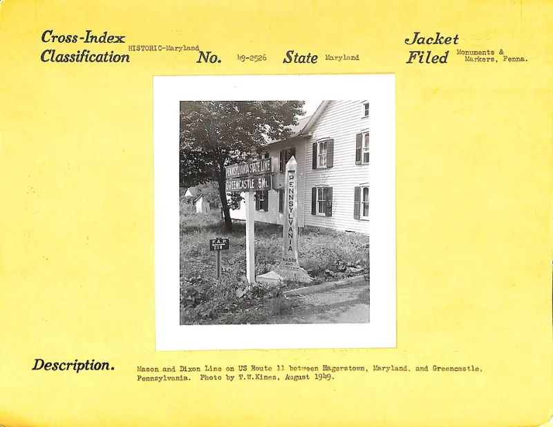
Photo: Department of Commerce. Bureau of Public Roads. 8/20/1949-4/1/1967, Public domain, via Wikimedia Commons
Say "Mason-Dixon Line" and most Americans picture a scar across the map, the dividing line between North and South. But drive it yourself and something different happens. The line isn't a scar. It's a stitch — running through some of the gentlest, most beautiful farm country in the Mid-Atlantic, marked by stones that two English surveyors hauled through the wilderness in the 1760s.
This is a road trip you can do in a long weekend, mostly on two-lane roads, with almost none of it crowded. And the deeper story — about surveying, border wars, and families split by an invisible boundary — is one of the best in Pennsylvania.
First, the Backstory You Skipped in School
Charles Mason and Jeremiah Dixon weren't thinking about slavery when they arrived in 1763. They were astronomers dispatched from England to settle a border dispute between the Penn and Calvert families that had smoldered for decades — occasionally violently, in the so-called Conojocular War fought by settlers on both sides.
Working with remarkably precise instruments for the era, they ran their line westward for about 233 miles, placing stones every mile. Every fifth mile got a "crown stone" — a heavier marker carved with the Penn family crest on the north face and the Calvert crest on the south.
It was only later, as border states split over slavery, that the line took on its second, heavier meaning. Free soil on one side. Slave states on the other. Families, farms, and futures divided by a boundary drawn to settle a property squabble.
Day One: Where the Line Begins
Start in Chestertown-adjacent — no wait, start further north, where the line actually begins. The survey started at a spot on the Delaware, but the practical place to begin is the Mason-Dixon Historical Park area near Mount Morris, at the line's western Pennsylvania touchpoint, or better yet, work east to west and begin near New Freedom in York County.
Actually, the classic approach runs east to west:
- Begin near Oxford, Chester County, where the line crosses quiet farmland. Surviving original stones are scattered along the boundary — many on private land, so use the Pennsylvania Historical and Museum Commission's Mason-Dixon marker guides to find publicly accessible ones.
- Stop at the Christiana area, site of the 1851 Christiana Resistance, where an armed standoff between enslaved people seeking freedom, their pursuers, and local residents became a flashpoint in the national fight over the Fugitive Slave Act. The line's meaning was never abstract here.
- Lunch in Oxford or Kennett Square — Kennett's mushroom-country diners and bistros are worth the detour.
Day Two: Crown Stones and Border Towns
Dedicate day two to the stones themselves. The crown stones are the prizes — roughly 110 were set, and dozens survive. Notable publicly viewable stones sit near Delta, PA, where the line crosses the Susquehanna, and along rural stretches of York and Adams counties.
Two towns deserve your time:
- Delta, PA: A slate-quarry town where southern and northern labor traditions mixed for a century. Small, walkable, and largely undiscovered.
- Gettysburg, 30 miles north of the line: You don't need us to sell you on it, but standing at the Mason-Dixon stones and then driving to Gettysburg in the same afternoon makes the through-line brutally clear. This borderland bled for a reason.
The Quirks Worth Pulling Over For
Part of the charm is how strange the line gets. Surveying errors and boundary agreements left oddities along the route — the line's "resurvey" jogs, the Mason-Dixon Line crossing the Susquehanna twice on its zigzag path up the river, and roadside historical markers that seem to argue with each other about what the line "really" meant.
Bring a coin. Tradition says you should step across the line at a surviving stone — one foot in Pennsylvania, one in Maryland — because for a long moment in American history, that single step changed everything about the law you stood under.
Why This Drive Still Matters
The Mason-Dixon Line is one of the few places in America where you can physically touch the fault line of the Civil War without standing on a battlefield. The stones are modest. The country is calm. But the questions the line raises — about who drew our divisions, and what they cost — travel home with you.
Go in late spring or early fall, when the farm country is at its best and the two-lanes are easy. And go slowly. The whole point is the line itself.